


Perihal Pix4Dcapture
Pix4Dcapture turns your consumer drone into a professional drone mapping tool. A free companion to Pix4D photogrammetry software, Pix4Dcapture is the perfect tool to automatically capture image data - RGB, thermal - for optimal 3D models and maps. Process post-flight images easily on the cloud or desktop applications, producing georeferenced maps and models that are tailored to many industry needs.
Currently, the app supports and was tested for the following drones:
• DJI
- Phantom 4 Pro v2.0
- Phantom 4 Pro
- Phantom 4
- Mavic 2 Pro
- Mavic Pro
- Mavic Air
- Matrice 200
- Matrice 210
- Matrice 210 RTK
- Inspire 2
- Inspire 1 (Pro)
- Phantom 3 Professional
- Phantom 3 Advanced
- Phantom 3 Standard
- Matrice 100
- Spark
• Parrot
- Anafi with Skycontroller 3
- Anafi Thermal with Skycontroller 3 (RGB + Thermal Images)
- Bluegrass with Skycontroller 2
- Bebop 2 with Skycontroller 2
• Yuneec
- H520 with E90 camera and ST16S controller (compatible version available from support page)
Features and benefits:
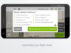
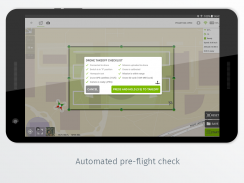
- Fully automated drone mapping
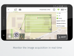
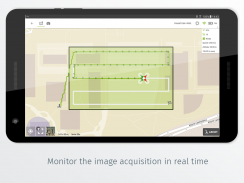
- Drone telemetry and camera live feed during the image acquisition
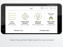
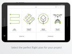
- Different flight plans for different needs
- Polygon Mission for general mapping
- Grid Mission for general mapping
- Double Grid Mission for better 3D model reconstruction
- Circular Mission for point-of-interest 3D model reconstruction
- Free Flight Mission for vertical object mapping with manual flight control
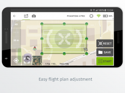
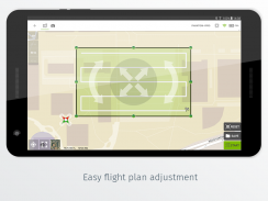
- Flight parameters for each mission - front & side image overlap, camera angle, altitude,
flight speed - can be adjusted based on the requirements of the area.
- Save or duplicate missions to fly the same area of interest several times
- Combine several missions into one project in the project manager
- Precise mission planning by importing KML/KMZ files
- Store the basemap with your flight plan using offline maps
- Change street/satellite basemap provider
- Seamless workflow with Pix4D’s processing software
- Automated image transfer from drone-to-device
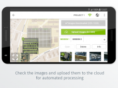
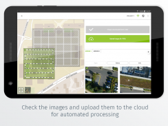
- Upload images directly from the device to Pix4D software in the cloud for processing (license required)
Post-flight processing & analysis using Pix4D’s software on cloud or desktop:
- Achieve survey-grade results from lightweight and compact cameras to large-frame metric cameras
- Usage of Ground Control Points (GCPs) for improving the relative and absolute accuracy of the model
- Generate and modify
- Point clouds
- Orthomosaics
- Digital elevation models (DSM/DTM)
- Index maps (e.g. NDVI)
- And more
- Measure distances, surfaces, and volumes
Important information:
Ensure you have the latest firmware installed on your drone and the app is up to date. The app follows the flight plan and does not avoid obstacles automatically. Pix4D accepts no liability for damage, injuries or legalities from the misuse of this app. Use only in safe environments.
Pix4Dcapture menghidupkan drone pengguna anda menjadi alat pemetaan drone profesional. Rakan kongsi percuma untuk perisian photogrammetry Pix4D, Pix4Dcapture adalah alat yang sempurna untuk menangkap data imej secara automatik - RGB, thermal - untuk model dan peta 3D yang optimum. Memproses imej pasca penerbangan dengan mudah pada aplikasi awan atau desktop, menghasilkan peta dan model georeferenced yang disesuaikan dengan keperluan industri.
Pada masa ini, aplikasi menyokong dan telah diuji untuk pesawat berikut:
• DJI
& nbsp; - Phantom 4 Pro v2.0
& nbsp; - Phantom 4 Pro
& nbsp; - Phantom 4
& nbsp; - Mavic 2 Pro
& nbsp; - Mavic Pro
& nbsp; - Mavic Air
& nbsp; - Matrice 200
& nbsp; - Matrice 210
& nbsp; - Matrice 210 RTK
& nbsp; - Inspire 2
& nbsp; - Inspire 1 (Pro)
& nbsp; - Phantom 3 Professional
& nbsp; - Phantom 3 Advanced
& nbsp; - Standard Phantom 3
& nbsp; - Matrice 100
& nbsp; - Spark
• Burung Parrot
& nbsp; - Anafi dengan Skycontroller 3
& nbsp; - Anafi Thermal dengan Skycontroller 3 (RGB + Thermal Images)
& nbsp; - Bluegrass dengan Skycontroller 2
& nbsp; - Bebop 2 dengan Skycontroller 2
• Yuneec
& nbsp; - H520 dengan kamera E90 dan pengawal ST16S (versi serasi yang tersedia dari halaman sokongan)
Ciri dan faedah:
& nbsp; - Sepenuhnya pemetaan drone automatik
& nbsp; - Telemetri dulang dan kamera hidup suapan semasa pemerolehan imej
& nbsp; - Pelan penerbangan yang berbeza untuk keperluan yang berbeza
& nbsp; & nbsp; - Misi Polygon untuk pemetaan umum
& nbsp; & nbsp; - Misi Grid untuk pemetaan umum
& nbsp; & nbsp; - Double Grid Mission untuk pembinaan semula model 3D yang lebih baik
& nbsp; & nbsp; - Misi Pekeliling untuk pembinaan semula model 3D yang menarik minat
& nbsp; & nbsp; - Misi Penerbangan Percuma untuk pemetaan objek menegak dengan kawalan penerbangan manual
& nbsp; - Parameter penerbangan untuk setiap misi - depan & amp; sisi imej bertindih , sudut kamera , ketinggian ,
& nbsp; & nbsp; & nbsp; & nbsp; & nbsp; kelajuan penerbangan - boleh diselaraskan berdasarkan keperluan kawasan tersebut.
& nbsp; & nbsp; & nbsp; - Misi Simpan atau pendua untuk terbang beberapa kali minat yang sama beberapa kali
& nbsp; & nbsp; & nbsp; - Gabungkan beberapa misi ke dalam satu projek dalam pengurus projek
& nbsp; & nbsp; & nbsp; - Perancangan misi yang tepat dengan mengimport fail KML / KMZ
& nbsp; & nbsp; & nbsp; - Simpan basemap dengan pelan penerbangan anda menggunakan peta luar talian
& nbsp; & nbsp; & nbsp; - Tukar pembekal basemap jalan / satelit
& nbsp; & nbsp; & nbsp; - Aliran kerja lancar dengan perisian pemprosesan Pix4D
& nbsp; & nbsp; & nbsp; & nbsp; - Pemindahan imej automatik dari drone-to-device
& nbsp; & nbsp; & nbsp; & nbsp; - Muat naik imej terus dari peranti ke perisian Pix4D di awan untuk diproses (diperlukan lesen)
Pemprosesan selepas penerbangan & amp; analisis menggunakan perisian Pix4D pada awan atau desktop:
& nbsp; - Mencapai hasil gred ukur dari kamera ringan dan kompak ke kamera metrik bingkai besar
& nbsp; - Penggunaan Titik Kawalan Ground (GCPs) untuk meningkatkan ketepatan relatif dan mutlak model
& nbsp; - Menghasilkan dan mengubah suai
& nbsp; & nbsp; - Titik awan
& nbsp; & nbsp; - Orthomosaik
& nbsp; & nbsp; - Model ketinggian digital (DSM / DTM)
& nbsp; & nbsp; - Peta indeks (mis. NDVI)
& nbsp; & nbsp; - Dan banyak lagi
& nbsp; - Ukur jarak , permukaan , dan jumlah
Maklumat penting:
Pastikan anda mempunyai firmware terkini yang dipasang pada drone anda dan aplikasinya adalah terkini. Aplikasi ini mengikuti pelan penerbangan dan tidak mengelakkan halangan secara automatik. Pix4D tidak menerima sebarang liabiliti untuk kerosakan, kecederaan atau undang-undang dari penyalahgunaan aplikasi ini. Gunakan hanya dalam persekitaran yang selamat.
Pix4Dcapture - Versi 4.11.0
(13-07-2021)Pix4Dcapture - Maklumat APK
Versi APK: 4.11.0Pakej: com.pix4d.pix4dmapperAplikasi dalam kategori sama
Anda juga mungkin suka...


